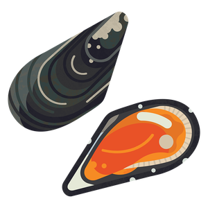
King scallop
Pecten maximus
What to check for
Location
Scotland (Shetland)
Technical location
Atlantic, Northeast, North Sea (North)
Caught by
Dredge
Certification
Marine Stewardship Council (MSC)
Rating summary
Information about Shetland king scallops indicates that the stock is growing, and there is no concern for the biomass or fishing pressure. All of the inshore (0-6nm) scallop dredge fishery is independently certified to Marine Stewardship Council (MSC) standards. Some appropriate management measures are in place, but improvements are needed to better control the impacts of dredging. Scallop dredging can be very damaging to seabed habitats and species. In Shetland, some areas are closed to scallop dredging, and the certified fishery is monitored to ensure impacts are reduced.Rating last updated November 2023
Technical consultation summary
Information about Shetland king scallops indicates that the stock is growing, and there is no concern for the biomass or fishing pressure. Route 2 (data limited) scoring has been applied to this rating owing to the lack of reference points for fishing pressure. King scallops are considered to have high resilience to fishing pressure. Stock assessments for scallops in Shetland are carried out by the University of the Highlands and Islands Shetland (UHI Shetland) on behalf of the Shetland Shellfish Management Organisation (SSMO). The most recent stock assessment was published in 2023, using data up to 2021. There is no direct measurement of biomass or fishing pressure. Instead, the health of the stock is indicated by landings per unit of fishing Effort (LPUE), measured as the number of scallops caught per hour of dredging. The stock has been above the target level since 2014. Therefore, there is no concern for the biomass. There is no recent measurement or indicator of fishing pressure (F) other than landings data. As the LPUE suggests that the stock is growing under current levels of catches, we consider there to be no concern for fishing pressure. Some appropriate management measures are in place to control scallop fishing in Shetland. Improvements are needed to better understand stock trends and control the impacts of dredging. All of the inshore scallop dredge fishery is independently certified to Marine Stewardship Council (MSC) standards. There is a harvest strategy based on LPUE. This indicates that management is responsive to the stock. However, monitoring a stock based only on fishery data can mask changes in the stock, and a more direct measure of the biomass would provide more confidence in stock trends. Licenses are used to control and reduce the number and engine power of vessels in the area. Other regulations include a minimum landing size, dredge limits, gear specifications and a curfew between 9pm and 6am. There are closed areas to scallop dredging to protect horse mussels, maerl, and seagrass. However, a large majority of the inshore area remains open to scallop dredging. Remote Electronic Monitoring (REM) has been voluntarily installed in the Shetland scallop dredge fleet. This could improve compliance and understanding of the fishery by tracking exactly where dredging is taking place. There is no information on whether REM on this fleet can be used to record catch and bycatch. The stock assessment, harvest strategy and management measures cover the 0-6nm zone only. Scallop fishing in the 6-12nm zone does not appear to be accounted for. Scallop dredging can be very damaging to seabed habitats and species. In Shetland, some areas are closed to scallop dredging, and the certified fishery is monitored to ensure impacts are reduced. Seabed habitats have been partially mapped as part of the Shetland Islands Marine Spatial Plan, and the state and trends of the habitats have been assessed where possible. As a result, a number of highly vulnerable habitats such as horse mussel beds, seagrass, and maerl were identified and closed to dredging. Although impacts from dredging are mitigated in the closed areas, there will inevitably be effects on the fished habitats. Scotland’s Marine Assessment 2020 predicts that 80% of the 0-12nm zone of the Shetland Isles is subjected to high levels of disturbance by fishing, although this does include other gears such as trawling. Exact habitat distributions are unknown as not everywhere has been surveyed. Trend data is lacking for many habitats. There is some conflicting information about the footprint of the dredge fishery. Certification reports refer to data from 2013-2016 indicating that it covers around 5.7% of the 0-6nm zone, while the Shetland Islands Marine Plan includes maps of dredge fishing grounds that are much more extensive. Therefore, while management is in place to protect vulnerable habitats, more data is needed to ensure that the impact of dredging is fully understood and mitigated.
How we worked out this Rating
Information about Shetland king scallops indicates that the stock is growing, and there is no concern for the biomass or fishing pressure.King scallop fishing in Shetland developed in the 1960s and landings have steadily increased since then. They peaked at around 1,400 tonnes in 2013, followed by a decline, but have since increased back to 1,400t.Route 2 (data limited) scoring has been applied to this rating owing to the lack of reference points for fishing pressure. King scallops are considered to have high resilience to fishing pressure.Stock assessments for scallops in Shetland are carried out by the University of the Highlands and Islands Shetland (UHI Shetland) on behalf of the Shetland Shellfish Management Organisation (SSMO). The most recent stock assessment was published in 2024, using data up to 2022.There is no direct measurement of biomass or fishing pressure. Instead, the health of the stock is indicated by landings per unit of fishing Effort (LPUE), measured as the number of scallops caught per hour of dredging. LPUE has steadily increased since data collection began in 2000, with 2022 showing the highest on record at almost 35. A target has been set for the LPUE (26), and if the stock falls below this level, additional management measures will be triggered. The stock has been above this target since 2014. Therefore, there is no concern for the biomass.There is no recent measurement or indicator of fishing pressure (F) other than landings data. The most recent available measure is from a stock assessment in 2016, which indicated that F was increasing but remained close to the long-term average. MMO data indicates that landings from Shetland between 2018 and 2022 averaged 1,265t. This is higher than the previous (2013-2017) average of 1,167t but close to the 10-year average of 1,216t. Landings in 2022 were 1,461 tonnes - the highest since 2010. However, the level of fishing effort (hours of dredging per year) has stayed constant. As the LPUE suggests that the stock is growing under current levels of catches, we consider there to be no concern for fishing pressure.In past assessments, there were measures of spawning stock biomass (SSB). SSB increased from 2001 to 2012, but then declined to below the target reference point in 2015. Since then, SSB measurements these have been too uncertain to be used. However, scallop surveys have been undertaken since 2007 and there may be a more comprehensive stock assessment by UHI Shetland in future years.The above stock assessment appears to cover inshore Shetland waters (0-6nm), which fall within the jurisdiction of the SSMO. However, a small number of king scallops are caught in the 6-12nm zone. As the stock assessment does not cover this area, it is unclear what the stock trends here would be.
Some appropriate management measures are in place to control scallop fishing in Shetland. Improvements are needed to better understand stock trends and control the impacts of dredging. All of the inshore scallop dredge fishery is independently certified to Marine Stewardship Council (MSC) standards.Almost all (over 99%) of the scallop catch from Shetland is by Scottish vessels, and around 96% of it is caught by dredging. The Shetland Shellfish Management Organisation (SSMO) manages and regulates shellfish fisheries within the 0-6nm zone. There is currently no Fishery Management Plan or quota, but there is a harvest strategy. The inshore fishery, covering 0-6 nautical miles from shore, has been certified since 2012.The harvest strategy uses landings per unit of fishing effort (LPUE, number of scallops caught per hour of dredging) as an indicator of stock status. If LPUE drops below a certain level (Target Reference Point, TRP), additional management measures are triggered to control fishing pressure. These measures can include preventing new vessels from entering the fishery, increasing the minimum landing size, spatial closures, or temporal restrictions such as limits on days at sea. If the LPUE falls below the lowest historical level (Limit Reference Point), the fishery will be closed. This indicates that management is responsive to the stock. However, monitoring a stock based only on fishery data (i.e. LPUE) can mask changes in the stock, and a more direct measure of the biomass would provide more confidence in stock trends.Effort in the fishery has been fairly static since 2010, at around 140,000 hours of dredging per year. Landings in that time have increased from around 3.5 million individuals to 5.3 million in 2022. Therefore, LPUE has also increased, suggesting that the stock is increasing under the current level of fishing pressure. LPUE has been above the TRP since 2014.The SSMO uses licenses to control and reduce the number and engine power of vessels in the area, and therefore the fishing effort. In 2022, 22 vessels were targeting scallops. Most proposals for fishing regulations have been made by fishermen, generally via the Shetland Fishermen's Association. The main regulations are:A minimum landing size of 100mm. Scallops are thought to mature at age 3 or around 80mm, although growth rates vary. Therefore, juveniles are protected. However, it is smaller than the MLS elsewhere in Scotland (105mm) and the UK (110mm), and may not adequately protect the breeding stock because scallop reproductivity increases with size.A maximum of 10 dredges per vessel within 0-6nm, and no limit beyond 6nm.A ban on hydraulic, suction and 'French' dredges, which are more damaging to seabed habitats.A ban on scallop fishing between 9pm and 6am to protect mobile benthic species.There are closed areas to scallop dredging to protect horse mussels, maerl, and seagrass. However, a large majority of the inshore area remains open to scallop dredging. As the impact of dredging on seabed habitat is a key impact of the fishery to limit, we do not consider all of the appropriate management measures to be in place.Detailed reporting is required by the SSMO, including area fished, hours towed, number of dredges used, target species, catch (in weight or numbers), discards, and interactions with Endangered, Threatened or Protected species. A penalty system has been developed, although it is unclear if it has been rolled out.To further improve monitoring of the fishery, certification reports indicate that Remote Electronic Monitoring (REM) has been voluntarily installed in the Shetland scallop dredge fleet. It pings vessel location every 10 seconds and has sensors on winches, which will distinguish between fishing activity and steaming. There are video cameras which can monitor the number of dredges being used. This could improve compliance and understanding of the fishery by tracking exactly where dredging is taking place. There is no published assessment on what impact this has yet had, although between August 2022 and July 2023 no major compliance issues were reported, with most infringements relating to late submissions of data. REM on this fleet is used to record dredge umbers, but not catch and bycatch.In 2023, the Scottish government confirmed that REM would be made mandatory on all scallop dredge vessels, but had not defined a timeline for this at the time of writing (November 2023). The implementation of REM across the scallop dredge fleet is very positive. MCS believes that Remote Electronic Monitoring (REM) with cameras is one of the most cost-effective tools fisheries managers have for delivering reliable fisheries data and for making informed management decisions. Fully accountable and fully monitored fisheries can improve collaboration and data accuracy, supporting stock recovery, improved selectivity, and minimisation of impacts on marine wildlife and habitats. However, this can only be fully realised if REM is used not only for locations of mapping fishing activity, but also documenting catch and bycatch, especially where there is a risk of impacts on vulnerable species and habitats.The stock assessment, harvest strategy and management measures cover the 0-6nm zone only. Scallop fishing in the 6-12nm zone does not appear to be accounted for. A Shetland Regional Inshore Fisheries Group was set up in 2023, joining a network of other non-statutory RIFGs around Scotland that cover the 0-12nm zone. However, they do not have powers to set byelaws or implement management measures. RIFGs aim to "improve the management of inshore fisheries" and "give commercial inshore fishermen a strong voice in wider marine management developments". In Shetland, the RIFG will work with the SSMO and will cover fisheries out to 12nm that are not included in the Shetland regulating order.
Scallop dredging can be very damaging to seabed habitats and species. In Shetland, some areas are closed to scallop dredging, and the certified fishery is monitored to ensure impacts are reduced.Most Shetland scallop catches (around 96%) are by dredging. The main environmental impact from dredging is its effect on the seabed. This impact varies depending on which habitats the dredging happens on (see below for more details). The certified fishery has taken some steps to reduce impacts on habitats, including closing vulnerable areas. However, some habitats remain at risk.Most dredging around Shetland appears to take place in the 0-6nm zone, and is covered by the MSC certification, but some fishing takes place in the 6-12nm zone. This rating covers the 0-6nm certified fishery.In Shetland, seabed habitats have been partially mapped as part of the Shetland Islands Marine Spatial Plan, and the state and trends of the habitats have been assessed where possible. As a result, a number of highly vulnerable habitats such as horse mussel beds, seagrass, and maerl were identified and closed to dredging. If additional sensitive seabed habitats are reported, there is a commitment to investigate and close the area to protect them.Although impacts from dredging are mitigated in the closed areas, there will inevitably be effects on the fished habitats. Scotland’s Marine Assessment 2020 predicts that 80% of the 0-12nm zone of the Shetland Isles is subjected to high levels of disturbance by fishing, although this does include other gears such as trawling. Exact habitat distributions are unknown as not everywhere has been surveyed. Trend data is lacking for many habitats. For ‘subtidal sediments’ and horse mussels, which are affected by dredging, environmental status has been categorised as ‘Some concerns’ and the trend is ‘No evidence’.There is some conflicting information about the footprint of the dredge fishery. Certification reports refer to data from 2013-2016 indicating that it covers around 5.7% of the 0-6nm zone, while the Shetland Islands Marine Plan includes maps of dredge fishing grounds that are much more extensive. Therefore, while management is in place to protect vulnerable habitats, more data is needed to ensure that the impact of dredging is fully understood and mitigated.Bycatch by dredges may also be of concern. Non-quota species are allowed to be caught as bycatch in UK scallop fisheries, as long as they comprise less than 5% of the total catch. In the certified fishery, interactions with vulnerable seabed species and other Endangered, Threatened and Protected (ETP) species are recorded in logbooks. There is a night time curfew to protect mobile seabed species that are more active at night. There has been no recorded bycatch of ETP species since 2010, when 4 juvenile common skate were caught but released alive. A 2010 report indicated that king scallops comprise around 62% of the weight of catches, with sea urchins, horse mussels and brown crab contributing around 22%.Bycatch is also recorded during annual scallop research surveys. The most recent survey in 2023 indicates that most bycatch (by number) is of starfish, which were assessed as having a small amount of non-lethal damage. Whelks, queen scallops and a number of crab, ray and fish species were also caught, with varying levels of damage. Based on the available data, bycatch does not appear to have significant impacts on species populations. However, most (around 75%) of the animals that scallop dredges interact with remain on the seafloor and are not recorded in bycatch surveys. They are often damaged, and so there may be impacts on populations in the affected areas.Remote Electronic Monitoring (REM) has been voluntarily installed in the Shetland scallop dredge fleet. This could improve compliance and understanding of the fishery by tracking exactly where dredging is taking place. However, there is no information on whether the systems installed can be used to record catch and bycatch. MCS believes that Remote Electronic Monitoring (REM) with cameras can improve data accuracy, supporting stock recovery, improved selectivity, and minimisation of impacts on marine wildlife and habitats. However, this can only be fully realised if REM is used not only for locations of mapping fishing activity, but also documenting catch and bycatch.About scallop dredging:A typical king scallop dredge, known as a Newhaven dredge, is a heavy steel frame with a chainmail net. There is a toothed bar at the front that penetrates the seabed, flipping the scallop into the net. Dredges are connected to a tow bar that travels over the seabed, and there can be up to 20 dredges per bar. The number of dredges and tow bars are limited by the engine power of the vessel, and by various legislation around the UK.On average, global studies estimate that scallop dredging penetrates seabeds by around 6cm, and can reduce community abundance and species richness by 8-12% per dredge pass. Recovery can take months or years, depending on the species affected. The impacts vary, depending on the type of seabed, the species that live there, and the level of natural disturbance from waves and storms. In more disturbed areas, the habitats and species may be faster growing and more easily able to recover. Sheltered and inshore areas are more likely to have slow-growing, delicate species, like maerl, seagrass, horse mussels and seafans. Sandy areas are generally less sensitive and more easily able to recover. Gravelly seabed communities are more susceptible because they are quite stable and therefore more likely to have larger, longer-lived species.Impacts can include:Removal of species from the seabed and reduction of biodiversity. In particular, it can change the composition of the ecosystem towards shorter lived and faster growing species that can more easily recover from dredging.Reduction in the complexity of the seabed, which can reduce the number of suitable habitats on which species can settle.Resuspension of sediments, which can smother species and prevent photosynthesis or filter feeding.
References
Cappell, R., Huntington, T., Nimmo, F., and MacNab, S. 2018. UK scallop fishery: current trends, future management options and recommendations. Report produced by Poseidon Aquatic Resource Management Ltd. Available at http://www.nwwac.org/_fileupload/Papers%20and%20Presentations/2019/Madrid_2019/1417%20Poseidon%20UK%20Scallop%20final%20report%2011_10_18.pdf [Accessed on 14.06.2022].Cappell, R., Keus, B. and Addison, J., 2018. Marine Stewardship Council Public Certification Report: SSMO Shetland inshore brown & velvet crab and scallop fishery. Prepared for The Shetland Shellfish Management Organisation by Acoura Marine Ltd. Published 12 July 2018. Available at https://fisheries.msc.org/en/fisheries/ssmo-shetland-inshore-brown-crab-and-scallop/@@assessments [Accessed on 07.07.2022].Cappell, R., and Addison, J., 2022. Marine Stewardship Council 3rd Surveillance Audit: SSMO Shetland inshore brown crab and scallop. Prepared for The Shetland Shellfish Management Organisation by LRQA. Published 13 May 2022. Available at https://fisheries.msc.org/en/fisheries/ssmo-shetland-inshore-brown-crab-and-scallop/@@assessments [Accessed on 07.07.2022].Cappell, R. & Addison. J., 2023. Marine Stewardship Council 4th Surveillance Audit: SSMO Shetland Inshore Brown Crab and Scallop. Prepared for The Shetland Shellfish Management Organisation by LRQA. Published 13 July 2023. Available at https://fisheries.msc.org/en/fisheries/ssmo-shetland-inshore-brown-crab-and-scallop/@@assessments [Accessed on 28.11.2023].Dobby, H., Fryer, R., Gibson, T., Kinnear, S., Turriff, J. and McLay, A. (2017) Scottish Scallop Stocks: Results of 2016 Stock Assessments. Scottish Marine and Freshwater Science Vol 8 No 21, 178pp. DOI: 10.7489/2005-1. Available at https://data.marine.gov.scot/dataset/scottish-scallop-stocks-results-2016-stock-assessments [Accessed on 01.06.2022].Hiddink, J., Jennings, S., Sciberras, M., Szostek, C.L., Hughes, K.M., Ellis, N., Rijnsdorp, A.D., McConnaughey, R.A., Mazor, T., Hilborn, R., Collie, J.S., Pitcher, C.R., Amoroso, R.O., Parma, A.M., Suuronen, P. and Kaiser, M.J. 2017. Global analysis of depletion and recovery of seabed biota after bottom trawling disturbance. PNAS. 114:31, pp. 8301-8306. https://doi.org/10.1073/pnas.1618858114.Howarth, L. M. & Stewart, B. D. 2014. The dredge fishery for scallops in the United Kingdom (UK): effects on marine ecosystems and proposals for future management. Report to the Sustainable Inshore Fisheries Trust. Marine Ecosystem Management Report no. 5, University of York, 54 pp. Available at http://eprints.whiterose.ac.uk/79233/1/Howarth_and_Stewart_2014_Ecosystem_effects_management_of_UK_scallop_fisheries.pdf [Accessed on 14.06.2022].Lambert, G.I., Jennings, S., Kaiser, M.J., Davies, T.W. and Hiddink, J.G., 2014. Quantifying recovery rates and resilience of seabed habitats impacted by bottom fishing. Journal of Applied Ecology. 51:5, pp. 1326-1336. https://doi.org/10.1111/1365-2664.12277.Lawler, A., Nawri, N., Harvey, J., Clarke, D., Vanstaen, K., and Benedet, R., 2023. Assessment of king scallop stock status for selected waters around the English coast 2021/2022. Cefas: A Defra and Industry Funded Project. March 2023. 78pp. Available at https://assets.publishing.service.gov.uk/government/uploads/system/uploads/attachment_data/file/1149470/SCE_assessment_report_2022_main_v2.pdf [Accessed on 05.06.2023].MMO, 2023. UK sea fisheries annual statistics report 2022. Marine Management Organisation. Published 28 September 2023. Available at https://www.gov.uk/government/statistics/uk-sea-fisheries-annual-statistics-report-2022 [Accessed on 13.11.2023].Palomares, M.L.D. and Pauly, D. Editors. 2023. SeaLifeBase: Pecten maximus, Great Atlantic scallop. Available at https://www.sealifebase.ca/summary/Pecten-maximus.html [Accessed on 28.11.2023].Pitcher, C.R., Hiddink, J.G., Jennings, S., Collie, J., Parma, A.M., Amoroso, R., Mazor, T., Sciberras, M., McConnaughey, R.A., Rijnsdorp, A.D., Kaiser, M.J., Suuronen, P. and Hilborn, R., 2022. Trawl impacts on the relative status of biotic communities of seabed sedimentary habitats in 24 regions worldwide. PNAS 119:2. https://doi.org/10.1073/pnas.2109449119.RIFG, 2023. Regions: Shetland. https://rifg.scot/region/shetland [Accessed on 28.11.2023].Sciberras, M., Hiddink, J.G., Jennings, S., Szostek, C.L., Hughes, K.M., Kneafsey, B., Clarke, L.J., Ellis, N., Rijnsdorp, A.D., McConnaughey, R.A., Hilborn, R., Collie J.S., Pitcher, C.R., Amoroso, R.O., Parma, A.M., Suuronen, P. and Kaiser, M.J. 2018. Response of benthic fauna to experimental bottom fishing: A global meta- analysis. Fish and Fisheries, 19:4, pp 698-715. https://doi.org/10.1111/faf.12283. [Accessed on 15.06.2022].Scotland’s Marine Assessment, 2020. Predicted extent of physical disturbance to seafloor. Available at https://marine.gov.scot/sma/assessment/predicted-extent-physical-disturbance-seafloor [Accessed on 10.06.2022].Scottish Government, 2023. News: New fisheries measures announced. Published: 14 August 2023. Available at https://www.gov.scot/news/new-fisheries-measures-announced/ [Accessed on 30.11.2023].Scottish Government, 2023. Publication - FOI/EIR release: Shetland Shellfish Management Organisation (SSMO) and MSC surveillance audit: EIR release. Published: 14 August 2023. Available at https://www.gov.scot/publications/foi-202300367414/ [Accessed on 29.11.2023].Shetland Islands Marine Planning Partnership, 2021. Shetland Islands Regional Marine Plan. NAFC Marine Centre UHI pp 158. Available at https://www.shetland.uhi.ac.uk/t4-media/one-web/shetland/research/document/marine-spatial-planning/sirmp/SIRMP_2021_Amended_Version.pdf [Accessed on 07.07.2022]. Shetland UHI, 2023. Shetland Shellfish Stock Assessment 2022 - Summary Report: King Scallop Fishery. Prepared by University of the Highlands and Islands Shetland for the Shetland Shellfish Management Organisation (SSMO). Available at https://www.ssmo.co.uk/site/assets/files/1553/king_scallop.pdf [Accessed on 28.11.2023].Shucksmith, RJ, 2017. Shetland Islands Marine Region State of the Marine Environment Assessment. NAFC Marine Centre UHI. Report for the Shetland Islands Marine Planning Partnership. pp 172. Available at https://www.shetland.uhi.ac.uk/t4-media/one-web/shetland/research/document/marine-spatial-planning/state-of-environment-assessment/shetland-state-of-the-marine-environment-assessment-april-17.pdfSSMO, 2023. Shetland Shellfish Management Organisation Maps: Overview of Closed Areas. Available at https://www.ssmo.co.uk/site/assets/files/1480/21-9-2020-smp.jpg [Accessed on 28.11.2023].SSMO, 2023. Shetland Shellfish Management Organisation Regulations. Updated August 2023. Available at https://www.ssmo.co.uk/site/assets/files/1/ssmo_regulations.pdf [Accessed on 28.11.2023].WWF, RSPB and MCS, 2022. TransparentSea: Protecting our ocean using Remote Electronic Monitoring with cameras. Available at https://www.mcsuk.org/ocean-emergency/sustainable-seafood/our-sustainable-seafood-work/transparentsea/ [Accessed on 30.11.2023].
Sustainable swaps
Learn more about how we calculate our sustainability ratings.
How our ratings work